H.-J. Herzog, U. Schubert, G. Vogel, DWD, Potsdam
At the Deutscher Wetterdienst (DWD) an internal project named LITFASS is running. The aim of that project is to determine the representative turbulent fluxes over heterogeneous land surfaces by long-term observation and simulation. In this way the project is taken advantage of the given infrastructure of the Research Division at the DWD, where model research capacity is brought together with the existing measurement capacity at and around the Meteorological Observatory Lindenberg (MOL).
The simulation component of LITFASS consists of a very high resolving model, derived from the new operational nonhydrostatic compressible Lokal-Modell (LM) which is designated as LLM (LITFASS-Lokal-Modell). The strict relation to the LM is deliberately organized in order to have a high degree of consistence by using a unified programme code, having simular dynamics, numerics and a close reference to mutual validation of LM/LLM over the defined Lindenberg observational and simulation area. The integration area covers the planetary boundary layer in the vertical up to 3 km with 39 model layers. These layers are very thin near the surface. The horizontal size of the area corresponds to a typical meso-gamma scale model gridbox of about 14x14 km2 with 145x145 gridpoints at a horizontal grid spacing of dx = 96.5 m. A detailed physiographic description of the underlying surface is taken into account.
In contrast to common LES models used under clearly defined and controlled conditions, the LLM is aimed at operating under general meteorological circumstances. As a typical property the LLM is driven by time-dependent measured vertical profiles (composed from radiosonde, windprofiler, RASS, micro-wave sounding, tower measurements etc., available at MOL) and surface-based measurements (of radiation, precipitation, soil properties) supported by satellite information over a realistic surface for a great variety of weather situations.
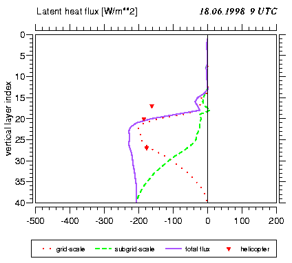
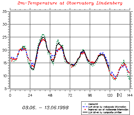
Concerning an extended measurement compaign LITFASS '98, 6 of 20 consecutive simulation days are shown in Fig. 1 for the 2m-temperature at the MOL-gridpoint where the measured time variation is plotted against three different LLM runs ( one run driven by radio sounding; the repetation of that run, but with improved incorporation of radiosonde information into initial and boundary data; a third run from 9.06. - 12.06.98 with available composite profile driving and hourly boundary data updating). Fig. 2 shows an LLM-simulated vertical profile of the latent heat flux (grid-scale and subgrid-scale contribution), horizontally averaged over the leg of a helicopter flight and the measurement from it in three altitudes.
The greatest deal of LLM test integrations for this still running project were and will be run on the ECMWF computer. Thus, on the VPP 700 a 24h-simulation over an 145x145x39-grid, with a 2 second-timestep, using 1(x)*16(y) vector processors, needs a computing time of 7 hours with a vector efficiency of 73 per cent. In this way the computing consumption at the Centre for 2000 amounts to 403698 Billings Units, which corresponds to about 420 24h-LLM-simulations.
Fig. 1: Measured vs. simulated time-variation of 2m-temperature